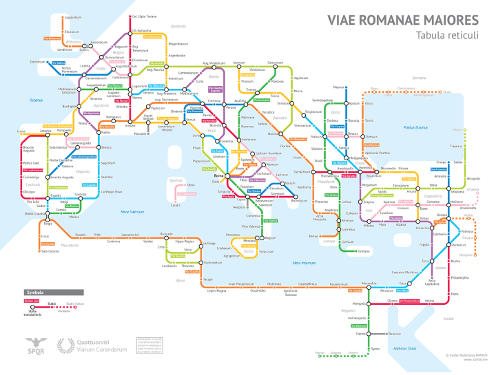
The map above is tube / subway style map of the major Roman roads around 125 AD. It is the amazing work of Sasha Trubetskoy and is largely based off the ORBIS Model of the Roman World and The Pelagios Project.
According to the author in summer time it would take you two months to walk on foot from Rome to Byzantium (later Constantinople and now Istanbul) or around one month by horse. However, if you took a boat it could be done in around 25 days.
The author then goes on to list of how they came up with road names:
Here’s a list of the roads that have authentic names and paths:
- Via Appia
- Via Augusta
- Via Aurelia
- Via Delapidata
- Via Domitia
- Via Egnatia
- Via Flaminia
- Via Flavia (I, II, III)
- Via Julia Augusta
- Via Lusitanorum
- Via Militaris
- Via Popilia
- Via Portumia
- Via Salaria
- Via Tiburtina
- Via Traiana
- Via Traiana Nova
Some roads have real names but were modified somewhat:
- The Via Latina I combined with the Via Popilia. In reality the Popilia ended at Capua, and the Latina went from Capua to Rome.
- Via Aquitania only referred to the road from Burdigala (Bordeaux) to Narbo (Narbonne).
- Via Asturica Burdigalam similarly only refers to the Astrurica-Burdigala section.
- “Via Claudia” is not a real name, but refers to a real continuous road built by Claudius.
- Via Hadriana was a real road in Egypt, but it refers to a slightly different section than the green route.
- The name “Via Maris” is considered to be a modern creation, referring to real ancient trade road whose real name has been lost to history.
- Via Valeria only referred to a section of the yellow Sicilian loop.
- The roads around Pisae, Luna and Genua had several names for different sections, including Via Aemilia Scauri. Sometimes “Via Aurelia” referred to the entire road from Rome to Arelate.
- Via Sucinaria is the Latin name for the Amber Road, a trade route from the Baltic region to Italy that carried amber as a valuable good. It probably was not used to refer to a single literal road.
- Via Gemina and Via Claudia Augusta are real names that referred to small parts of the routes marked on the map.
The other roads have relatively uncreative names that I invented, usually based on a place that they pass through.
You can see a full size image of the map here.
Enjoy this post? Please help us by spreading the word:

P.Ansem says
Hi,I miss the Limes Germanicus in the Netherlands,shouls be north west of Col. Ulpia Traiana,Claudius did made the start.
Luca Cossutti says
Ci sono diversi errori…
Luca Cossutti says
Via Annia: Mestre-Concordia-Auileia-Prosecco-Basovizza-Fiume (SS.14)
Via Gemina: Auileia-Staranzano-Ronchi-Doberdò-Slivia-Sgonico-Prosecco-Trieste-Monstepaccato-Basovizza-Lipizza-Divaccia-Senosecchia-Postumia-Lubiana
Via Electra: Auileia-Grandisca-Valle del Vipacco-Longatico-Lubiana
Via Flavia: Trieste-Pola
Via Annia Aleitha Fiume-Costa Dalmata-Costa Albanese-Grecia
Via Postumia: Capisaldi: Genova e Torino-Tortona-Cremona: biforcazione A) per Verona-Vicenza-Casarsa-Codroipo-Palmanova B) Cremona-Mantova-Strada Statale n 10
Via Aurea o Drusilla Augusta: Milano-Monza-Olginate-Lecco-Spluga-Augusta
Via Zoia: Genova-Giovi (Zoia)-Tortona-Pavia-Milano-Como-Bellinzona-Passi Svizzeri-Zug-Zurigo-Danubio/Reno
Via Severiana Augusta: Milano-Rho-Sesto Calende-Domodossola-Sempione-Valle del Rodano