• Skip to main content
  • Skip to primary sidebar

Brilliant Trains

Blog

November 13, 2018

There’s Something Missing From This East German Transit Map

There's Something Missing From This East German Transit Map

Map published by Mark Ovenden via Big Think

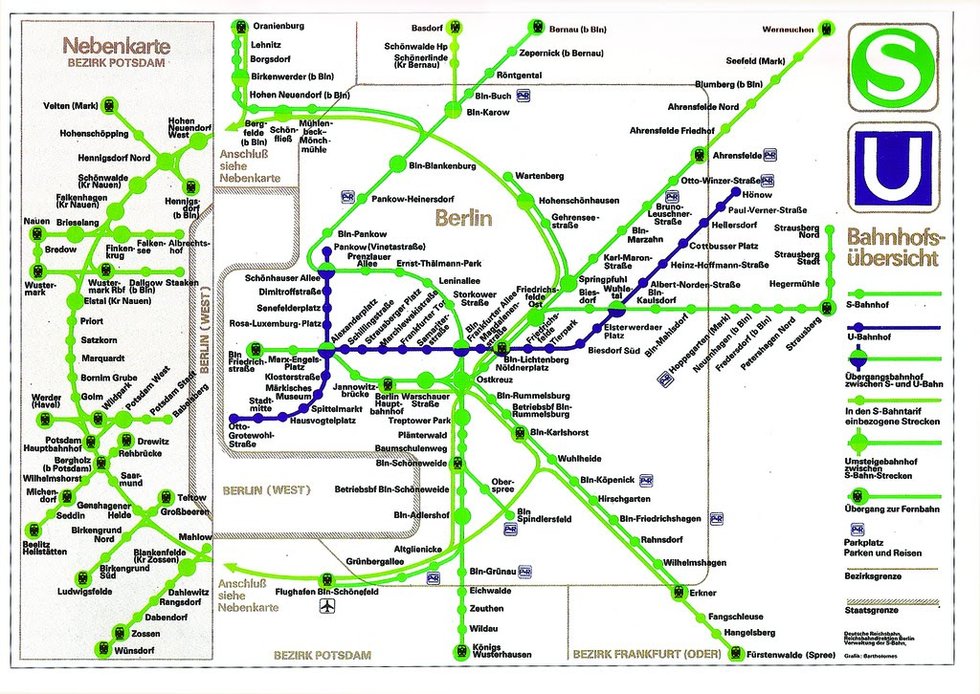
The map above is an East German transit map showing U-Bahn (Underground) and S-Bahn (Suburban) train lines in Berlin. However, if you look closely, you might notice something’s missing.

[Read more…] about There’s Something Missing From This East German Transit Map

Filed Under: history, Maps

May 23, 2018

What The Tube Map Could Have Looked Like If Proposals From 1946 Had Been Implemented

What The Tube Map Could Have Looked Like If Proposals From 1946 Had Been Implemented

Map created by reddit user Not_Quite_Vertical (Ali Carr). Click for full sized version

The map above shows what the Tube Map might have looked like had proposals from 1946 had been implemented. The plans are nothing if not ambitious, especially for a country that still had rationing in effect following the devastation of World War 2.

The source for these plans was the Railway (London Plan) Committee: report to the Ministry of War Transport 21st January 1946.

Some highlights include:

[Read more…] about What The Tube Map Could Have Looked Like If Proposals From 1946 Had Been Implemented

Filed Under: Maps

June 7, 2017

Roman Road Tube Map Circa 125 AD

Roman Road Tube Map Circa 125 AD

Map created by Sasha Trubetskoy

The map above is tube / subway style map of the major Roman roads around 125 AD. It is the amazing work of Sasha Trubetskoy and is largely based off the ORBIS Model of the Roman World and The Pelagios Project.

[Read more…] about Roman Road Tube Map Circa 125 AD

Filed Under: history, Maps

April 17, 2017

Amtrak After Trump’s Proposed Budget Cuts

Amtrak After Trump's Proposed Budget Cuts

Map crated by Cameron Booth at Transit Maps

The map above shows what Amtrak services might look like if President Trump’s budget cuts go through as planned. According to the National Association of Railroad Passengers press release:

[Read more…] about Amtrak After Trump’s Proposed Budget Cuts

Filed Under: Maps Tagged With: amtrack

January 16, 2017

Mini Metros – 220 Shrunken & Simplified Transit System Maps

Mini Metros

Maps by Peter Dovak at Transit Oriented

The 8 maps above are just a sample of the 220 metro and light rail system maps from around the world that have been shrunken and simplified by Peter Dovak at Transit Oriented.

You can see the complete list of mini metro maps below:

[Read more…] about Mini Metros – 220 Shrunken & Simplified Transit System Maps

Filed Under: Maps Tagged With: metro

August 7, 2016

Tube Map of Summer Olympic Host Cities 1896-2020

Tube Map of Summer Olympic Host Cities

Map created by AirTravelGenius.com

The tube or metro style map above shows all the host cities of the Summer Olympic Games from 1896-2020. They’ve grouped them by 4 eras: pre-World War 1, interwar years (or pre-World War 2), Post World War 2 – Cold War games and finally the Modern games.

[Read more…] about Tube Map of Summer Olympic Host Cities 1896-2020

Filed Under: Maps Tagged With: Olympics

  • Go to page 1
  • Go to page 2
  • Go to Next Page »

Primary Sidebar

Top Destinations

  • Euston Station
  • Gatwick Airport
  • Manchester Airport

Accommodation

  • Hotels Near Euston Station

Recent Posts

  • There’s Something Missing From This East German Transit Map
  • What The Tube Map Could Have Looked Like If Proposals From 1946 Had Been Implemented
  • Roman Road Tube Map Circa 125 AD
  • Amtrak After Trump’s Proposed Budget Cuts
  • Mini Metros – 220 Shrunken & Simplified Transit System Maps

Blog · Contact · Privacy Policy · Copyright & Fair Use
Copyright © 2023