• Skip to main content
  • Skip to primary sidebar

Brilliant Trains

January 16, 2017

Mini Metros – 220 Shrunken & Simplified Transit System Maps

Mini Metros

Maps by Peter Dovak at Transit Oriented

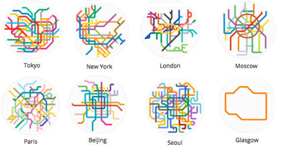
The 8 maps above are just a sample of the 220 metro and light rail system maps from around the world that have been shrunken and simplified by Peter Dovak at Transit Oriented.

You can see the complete list of mini metro maps below:

Mini Metros - 220 Simplified Transit Maps

If you like these maps, you can buy prints on his website here.

Stop throwing money away on train tickets!

Get e-mail notifications when advance tickets go on sale and save up to 70%:

Filed Under: Maps Tagged With: metro

Reader Interactions

Comments

  1. David Quick says

    July 4, 2019 at 5:49 pm

    The links to the prints are broken.

    Reply

Leave a Reply Cancel reply

Your email address will not be published. Required fields are marked *

This site uses Akismet to reduce spam. Learn how your comment data is processed.

Primary Sidebar

Top Destinations

  • Euston Station
  • Gatwick Airport
  • Manchester Airport

Accommodation

  • Hotels Near Euston Station

Recent Posts

  • There’s Something Missing From This East German Transit Map
  • What The Tube Map Could Have Looked Like If Proposals From 1946 Had Been Implemented
  • Roman Road Tube Map Circa 125 AD
  • Amtrak After Trump’s Proposed Budget Cuts
  • Mini Metros – 220 Shrunken & Simplified Transit System Maps

Blog · Contact · Privacy Policy · Copyright & Fair Use
Copyright © 2023